Hello Again 
Still in English, my appologies...
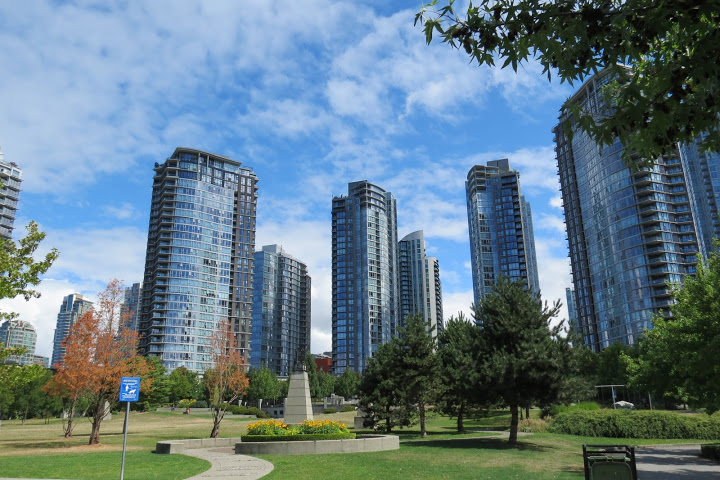
After some urban quality time  ...
...
My brother and I headed for the mountains again!
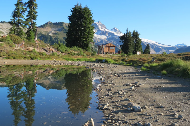
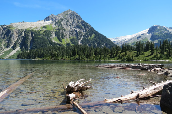
We made it back to Garibaldi Provincial Park, this time near the town of Squamish (just over 60 KM north of Vancouver). An 18 KM gravel road got us to the Elfin Lakes trail head and we started the gradual climb up the lakes. Its 11 KM from the trail head to the small lakes; mostly uphill but never steep (I don't have the elevation gain in my head now); took us about 3 hours (including stops). The trail begins in forest, on Jeep road and it goes on that way for about half the way until it gets to a shelter at a place called Red Heather. This section of trail offers little views (except for an opening or two, with very nice views towards the bay and the famous Chief: an impressive huge rock formation) but it does not lack interest as it is dotted by berry bushes (Salmon Berries, Thimbleberries & Blackberries) and an occasional... bear poop!
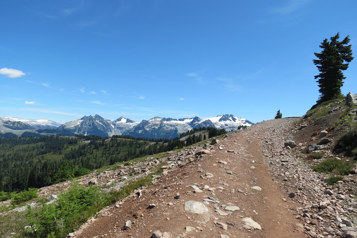
Beyond the shelter the views opens - and are quite magnificant! mouuntains, glaciers, forests... - and the trail changes into a "proper" hiking trail (although not all the way, it is wider again towards the lakes).
Elfin Lakes themselves (there are 2) are quint but small, with sandy bed. One (the smaller) lake is used for drinking only (water must be treated!) and the other, slightly larger, lake is used for swimming (the water are not too cold).
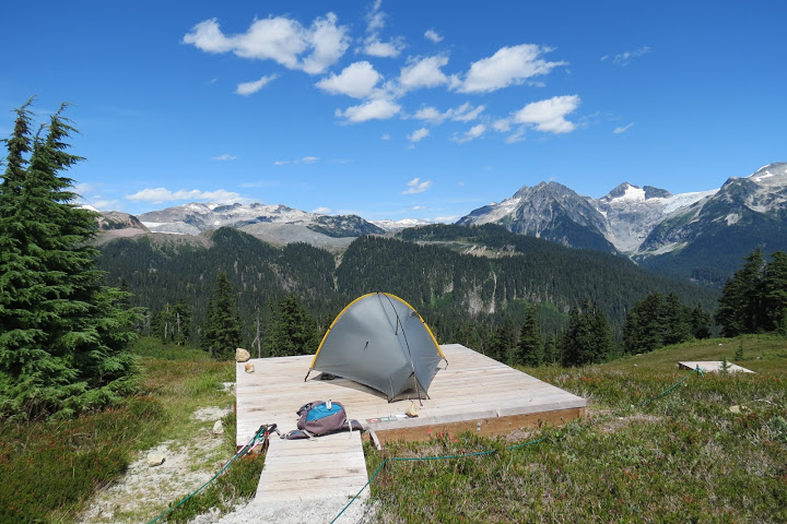
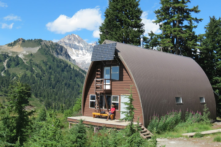
There's a ranger station right by the larger lake, a campground (AWESOME! with 2 outhouses, bear poles - for hanging food - and a cooking shelter; all tents - there are 18 spots, I think - are built on wooden platforms) just past the smaller lake & a hut (sleeps 33 on sleep benches on the 2nd floor; has a basic kitchen with propane gas for cooking and an eating area - very nice!) just a few steps farther in the woods.
The major attraction in this truly magnificant camp site are the views!!!
I'll let the photos explain:
I take it you are all convinced 
Either way... my brother settled in the hut (which was almost empty) and I set out to chose a platform and set up my BRAND NEW MOMENT DW TARP TENT!!! yes, I have decided that the SMD Trekker is not the best tent for me and, after much deliberation (with myself) - ordered the Moment; this was to be my "test run".
I will not get now into why I decided to try another tent but I can say that the Moment was very easy to set up and I think its a love story in the making (when I get back home, I will try to compare the 2 tents and give my final and very personal opinion - please remind me if you are interested and I... forget or don't get to it).
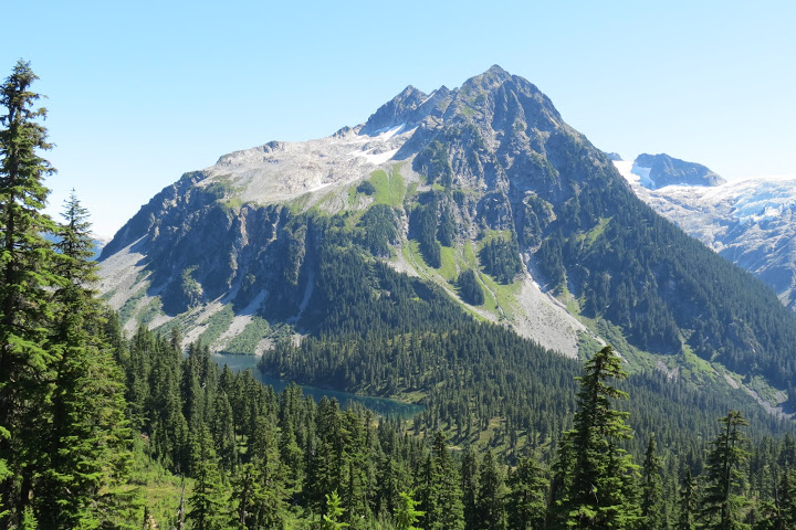
After setteling in, we set out on a short hike called "The Saddle"; I am not sure how long it is... but something in the area of 4 KM return trip from camp; it climbs up a saddle between the Gargoyles (nice rock formations, not all that pretty from below but quite interesting once above) and Columnar Peak... Its not such a huge climb, just a bit steep and slippery (scree) at the top. I think it took us about 2 hours including a long stop (of about 30 minutes) once we made it up; the saddle offers magnificant views of Garibaldi Mountain and its Glacier and side-peaks.
On returning to camp we jumped into the lake, filtered water, made dinner, etc... camp routine with the best of views; it was a hot day and a warm night with full moon and I actually had a (relatively) decent night sleep in my little new tent.
The next morning (~8:45) we set out on a day hike to Mamquam Lake; its 11 KM to the lake from our campground and it was hot... the trail is often exposed with little or no shade; it goes up and down most of the time, though it is never truly steep and without the hit the return trip would make a moderately difficult day hike at best (for "serious" hikers, in-shape, of course).
The area is surrounded with high mountains and receding glaciers; glacial activity really shows - the ground is extremely unstable in several sections, with many rock and land slides, recent or old; you pass several glacial moraines that are very dusty and much of the trail's near surroundings are barren with little vegetation; there are a few forested patches and several streams but all in all - it has a desolate, dead feeling about it.
About half way, by a side-trail climbing to a "hill" called Opal Cone, there's a magnificant glacial lake called Lava Lake - striking blue in the "desert-like" ground (there are actually 2 lakes, a smaller one is just higher up and hardly visible from this trail)
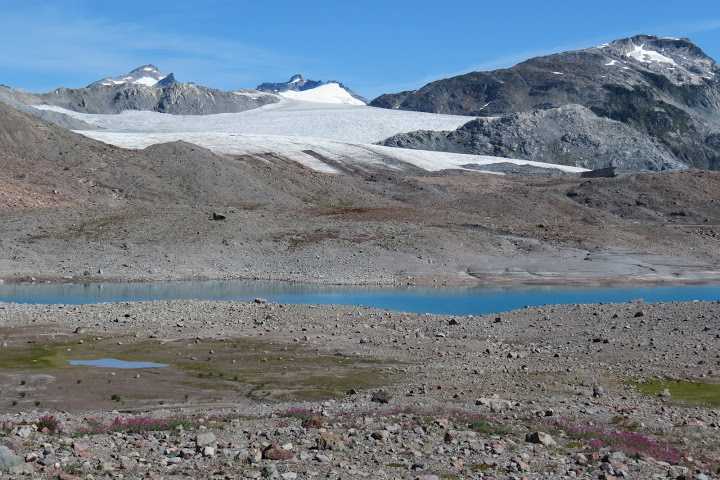
There's more, mostly very gentle, ups and downs, past Lava Lake, crossing of a bussy stream on a metal bridge and some more hiking in "dead" terrain, and you are finally above a dense, dark-green forest bordering magnificent high mountains with a hanging glacier at the top (these are Mamquam Mountain and its beautiful glacier).
This section of trail is a true delight!
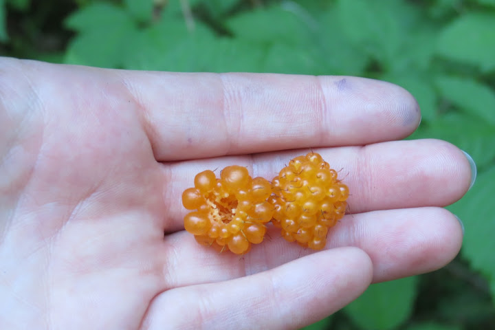
First, there's shade - at last! (I was really struggling with the hit and burning sun today); next - the views are AMAZING! not just the far-views, in this section beauty is all around you, I loved it!; finally - the trail snaking down the forest is dotted with so many berry bushes........
By the time we made it to the lake shore, our hands were stained with purpple and blue 
There used to be a tiny camp site by the lake shore (only 3 platforms and no facilities) but it was closed just 2 days before due to heavy bear activity (no wonder, given the plentiful food and abundant water) as well as cultural sensitivity (the place is, apparantly, sacared to the natives). The closure is permanent and work on a new location, just before the drop to the forest starts, is about to start (according to 2 rangers we met on our way).
We planned a long rest by the lake and a swim in its not-too-cold-on-such-a-hot-day water but the lake-side was infested with so many god damn flies.......... we sat for a while, tried to eat our lunch, dipped in the lake water and... sadly, packed up and... run away 
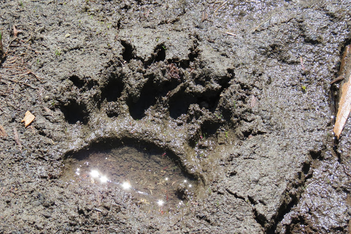
We did see 2 massive bear-paw prints accompanied by a small one in the mud by the lake!!! which got us both quite excited and me slightly scared...
I think it took us about 3 hours to get to the lake.
The way back up the forst took us longer then it would if not for those god damn berries  but we finally made it back into the burning sun.
We stopped to filter water by a pretty stream down a very dead valley (it was unpleasant to do by the lake because of the flies so we headed back up with little water knowing that there's a good source ahead). I took off my shirt soaking it in the cold running water before putting it on again and also dipped my head - it revived me quite a bit (there's absolutely no shade for about 1 hour of walk).
** a note to future hikers: search for the clear-water stream joining the grey, full of particals glacial, larger one just above the crossing metal bridge! its perfect for water collecting (but be sure to treat the water).
Past Lave Lake we took the side trail up Opal Cone; I think it is between 3-4 KM return (depending how much you scramble at the top). The trail climbs the glacial moraine (a pile of dirt, lets face it), very gradually at first, and is extremely narrow, knife-like with significant drops on both sides... There were beautiful views over the same gorgeous mountains and much improved views over the 2 Lava Lakes (including the smaller, higher one). It was also a surprisingly flowery short section and we enjoyed it very much.
Then the narrow trail ended and we started scrambling up a very steep, slippery section of the falling-apart mountain side... it was a bit scary for me and not so enjoyable; there was no apparent trail - I guess those who chose to climb farther make their own way from this point onward (its impossible to get lost, the mountain side is narrow). Finally the very steep section was over and we were on top; but it was a rather disappointing "peak". Opal Cone does not resemble a cone in any way that we could notice (not from below and not from the top). Its just an expansive "peak", very rocky and barren with many small "peaks" or small rocky hills on top... It is not the kind of peak that opens into new views; in fact, the only new element is a lookout on the Lava Glacier from above, including a small, very grey glacial lake forming at the glacier's base (that was not visible from the trail below); but this wasn't one of those very nice glaciers, it is smallish and greyish and looks rather... dirty 
After carefully wandering among rocks at the top for a while, looking for something exciting to be worthy of the scary ascent... we headed back down and continued our way back to camp.
As an after thought, we'd strongly recommend taking the side-trip but avoiiding the steep final section (just hiking to the final aparant section of trail on the moraine's "knife").
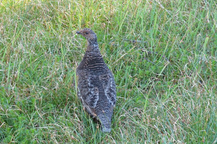
Our adventure was not over yet though as on our way back we scared a mother (I think...) Grouse with its 3 chicks and also came across a VERY FRESH BEAR POO that was not on the trail when we headed down!!!
We did not, however, get to actually SEE a bear on this trip (which I accept with very mixed feelings...) 

(note: other hikers we met in camp that evening came across a black bear just past the Red Heather shelter on the first half of the trail up Elfin Lakes!)
We arrived back in camp at around 17:30 (we only met 2 rangers in the forest above Mamquam lake in all our ~9 hours of hiking today!) and headed pretty much straight to the lake for a much needed, much deserved swim.
It was such a warm night that we sat outside, by the picnic tables, near the cooking shelter, with fellow campers until 11 PM. I only had my long, thermal shirt on (no jacket) - at elevation of about 1500 with glaciers and snowy peaks around, its a bit strange (BC is experiencing an out of character hot, dry summer and it had a very poor winter with relatively high temperatures and very little snow).
The full moon provided so much light that non of us used our flash-lights when cooking, walking around camp or doing our other chores.
We just sat there; eating and talking and laughing and getting to know each other, comparing camping gear and travel stories, with the glorious Garibaldi park mountains providing perfect background scenery, staring at the changing light as the sun set and the moon took over in the sky.
When I finally made it to my tent, tired from the hit and our hours of hiking, I thought, as my time in BC is ending, that my little brother and I (he has been living in Vancouver for over 10 years now) will cherish this special spot, this inspiring evening, this trip - for many years to come.
I pulled my fleece hat over my eyes to hide the moon light and I went to sleep...
Its almost an easy stroll, pretty much all downhill and never steep, downt he same 11-km-easy-to-follow trail back to the car; it takes more time then can be expected to get there though and you should already know why...
I am sorry if the information in this "report" is very lacking, its a bit difficult to travel and write at the same time.
I will very much try to write something more "complete" and "orderly" when I get back...
In the mean time, here's more information about this area\those hikes (these are the sites we used when planning our hike, in addition to a topo map, not an overly good one, we purchased in Vancouverl; there is absolutely no getting lost when there!):
http://www.vancouvertrails.com/trails/elfin-lakes/
http://www.vancouvertrails.com/trails/elfin-lakes/camping/
http://squamishhiatus.com/squamishhikes/elfin-lakes.html
http://www.env.gov.bc.ca/bcparks/explore/parkpgs/garibaldi/diamond.html
https://www.youtube.com/watch?v=SXiqK3KHPEs
http://www.trailpeak.com/trail-Mamquam-Lake-Garibaldi-Provincial-Park-near-Squamish-BC-6996
http://www.ihikebc.com/trips/2014/trip072-01MamquamLakeTrailHikeGaribaldiProvincialPark.htm
(important note: as I said, this area is ever-changing; be ready for trail divertions, changes in campsite locations, etc. - you MUST check out thos changes right before you set out to go)
נערך ע"י משתמש יום ראשון 02 אוגוסט 2015 03:01:03(UTC)
| סיבה: לא צויינה